

Marking and Mapping Trails
Markers on the trail should be selected for their visibility. Blue or red plastic surveyors ribbon is effective, as are four-inch metal diamonds and painted can tops. If at all possible, each trail should have its own color code. While these markers should not interfere with the natural beauty of the trail, they should be highly visible in a storm or low light situation. A skier should be able to see from one marker to the next in a blizzard to find his way.
Trailhead signs are another must. They should give the name of the trail, its length and its difficulty. Individual difficulty signs are becoming more popular. Some ski areas make up their own trail difficulty symbols, while others are adopting the United States Ski Association (USSA) standards.
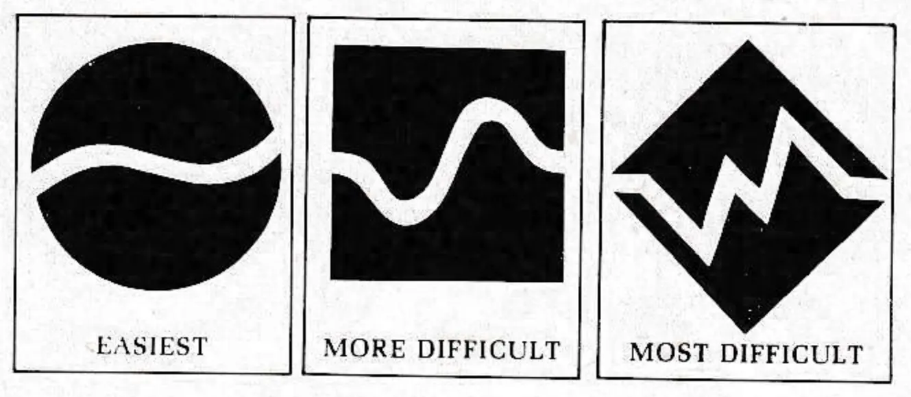
The USSA standards include a sign for easiest trails, a gently waving white line through a green circle, one for more difficult, a more pronounced wavy white line through a blue square, and one for most difficult, a jagged white line running through a black diamond.
The USSA trail standardization plan calls for trail length, width and grade uniformity within each difficulty classification nationwide. This means that an easiest classified trail in Maine will be virtually the same as one in Colorado or Oregon. While this is an interesting concept, most touring area operators will continue to grade their trail difficulty based on personal experience or the advice of the ski school director.
Along with trail difficulty signs at the trailhead, it’s important to have warning signs posted before every trail intersection and sharp downhill or curving trail sections. These signs should be placed at least 50 feet before the intersection or technically difficult trail section to allow skiers ample time to slow down or stop.
Many areas add that extra safety ingredient by posting the trail name in several spots along the trail. They reason that the fast growing number of beginners are largely newcomers to winter recreation. During solitary travel through the woods they need every assurance that they are on the right track and are not lost or strayed off their designated course.
Once the trails are completely marked, the maintenance crew can set out large scale trail maps. Most areas rely on one large map which shows their entire trail system. Placed near the base lodge or at the main trailhead, this sign shows where all the trails go, their difficulty, sights along the way and gives some rules of the road.
A new trail map that has caught on in the Midwest is the “you are here” type placed at major intersections on a trail system. A skier comes to an intersection and the map indicates his exact position in relation to the entire trail system. The “you are here” map is good in helping skiers maintain their orientation on trail systems that are cut deeply into a wooded area without high promentories or open meadows.
Many touring center operators are reporting that with increased numbers of skiers on their trails their handsome homemade wood trail signs are fast dissapearing as souvenirs. To counteract the theft problem, some centers are investing in heavier, less attractive metal signs. One Midwestern tour center operator has all his metal signs made in triplicate so he can immediately replace one that is vandalized or stolen.

At many Western touring areas, marking takes on a different twist. Those centers which bound wilderness lands are often required to provide wilderness travel information boards and sign out boxes for parties traveling off the touring center’s trails into the wilderness. The sign out system provides a record of skier travel which is extremely helpful should a rescue effort have to be mounted.
The final note on marking is far removed from the physical marking of the trail but is equally important. It is the trail map. Whether given free or for a slight charge, every touring center should have a detailed vest pocket sized trail map to help skiers find their way. The map should include basic safety information and the rules of the road. When it comes to trail marking, every piece of protection counts.
For more information on some of the topics discussed, contact the following sources:
Trail Marking in general: John Wiggin, Woodstock Touring Center, Woodstock, VT. 05091.
Trail Map: Trapp Family Lodge, Stowe, VT. 05672
Head of trail-map-boards: Royal Gorge Nordic Ski Resort, P.O. Box 178, Soda Springs, CA. 95728
Wilderness information and sign-out borads: Bob Mathews, MT. Bachelor Nordic Center P.O. Box 828, Bend, OR. 97701