


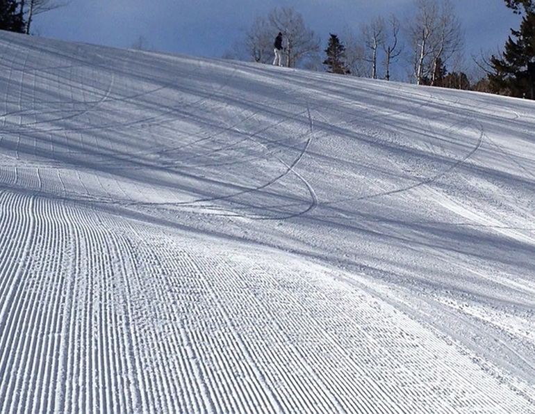
One of the wonderful ironies of modern grooming is that, in order to achieve snow-depth precision within an inch or two beneath a groomer’s blade, you must zoom all the way into Earth’s orbit and back, communicating with satellites to guide the operator’s judgment. Increasingly, such GPS technology is becoming an indispensable tool for resorts throughout North America as they seek not only to provide the best skiing surfaces possible but also to maximize grooming and snowmaking efficiency.
When the use of GPS technology first began to infiltrate the world of North American skiing about eight years ago, most resorts shied away from it. Not only did mountain ops people consider it expensive, they felt it lacked a proven track record. Taking the leap into what seemed like space-fantasy procedures right out of a futuristic Jetsons scenario was a bridge too far. Let someone else be the first to discover that the promises of grooming precision were overhyped or that the pricey technology was overly complicated or ineffective.
THE TRACK RECORD
Yet before GPS technology arrived at North American resorts, it had already been compiling a considerable track record of reliability. In Europe, where a dearth of natural snow early in the millennium had plagued many ski resorts, the use of GPS technology to maximize the efficient use of snowmaking was quickly accepted.
Perhaps more important, earlier GPS adopters in other industries, including agriculture, surveying, and construction, had already proven the technology’s effectiveness. As David Rowlett, North American sales manager for Leica Geosystems, notes in comparing snow-depth management to road construction or building-site grading: “It’s a different machine and different material, but the process is very much the same. GPS guidance is not new to the machine-control world.” Leica iCON Alpine Solution has collaborated with PRINOTH to develop a GPS-guided grooming technology.
GROWING ACCEPTANCE
Gradually, North American resorts are climbing aboard the GPS bandwagon. “There was always a question of how much snow we had in different places,” says Mike Hayward, snowmaking manager at Wachusett Mountain, Mass. The installation of a Snowright GPS system last year has eliminated that problem; as a result, on the snowmaking side, “we now know down to the gallon how much water we need,” says Hayward.
Representatives of the principal companies selling GPS systems agree that the North American market has been stirring over the last couple of years. Says Rick Hefley, national account manager for the ski industry for RDO Integrated Controls: “There has been an uptick in interest and customers. People now know what the technology is and the value of it.”
STATE OF THE MARKET
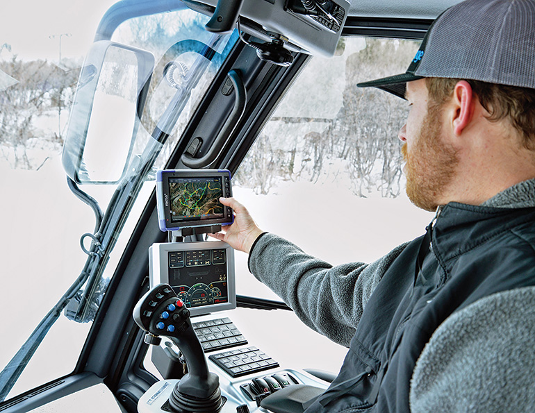
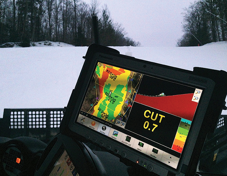
The major players in the North American GPS market currently are: PistenBully with its SNOWsat system; the SNOW HOW system, which brings together the Leica iCON Alpine Solution and PRINOTH; RDO with its Arena system; Snowright; and SnowGage, from Juniper Systems. Most feature variations on a similar theme, with operators in GPS-equipped machines working in tandem with a base station, all under the guidance of GPS signals. The operator in the groomer cab uses a monitor that, typically with color coding, visually displays when the blade is at an optimal level (or when an adjustment needs to be made).
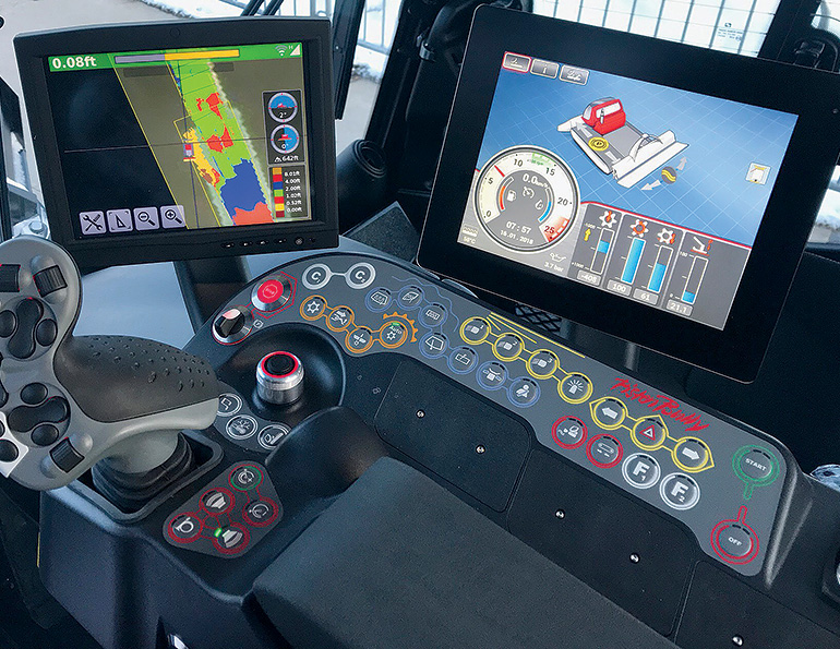 PistenBully’s SNOWsat system is one of a small handful of major players in the North American GPS market. Under the guidance of GPS signals, the groomers can monitor snow depth levels represented by color-coded segments, helping the groomer set an optimal blade level.
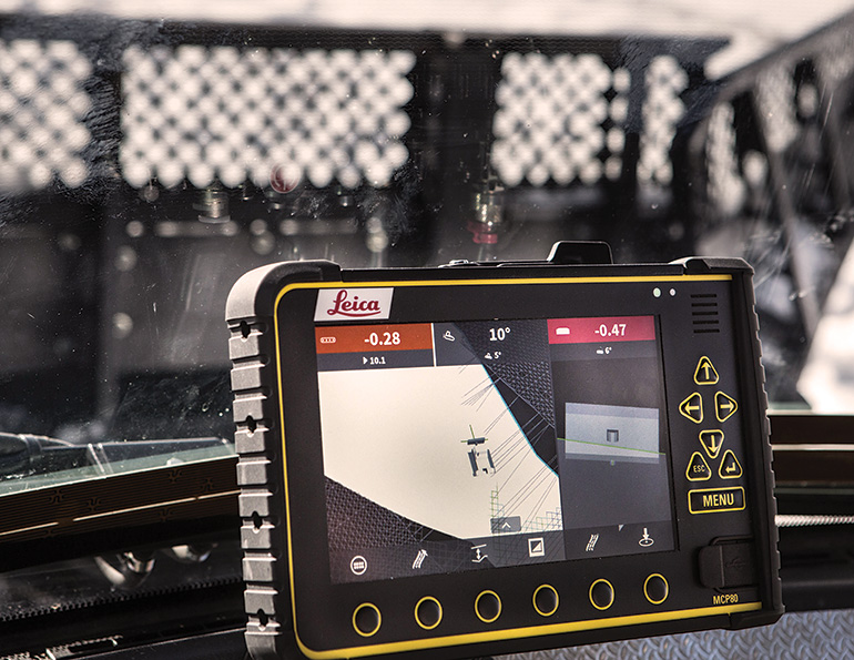
 Snow-depth management systems, such as PRINOTH’s SNOW HOW and the Leica iCON Alpine Solution, can help expedite new operator training.
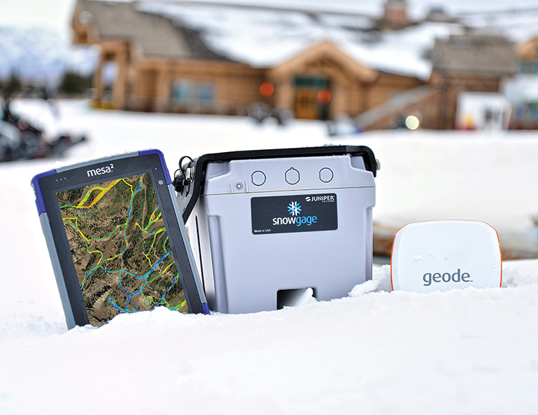 SnowGage uses a sensor on the belly of the groomer rather than digital mapping to deliver snow base depths.
 Display monitors integrate easily into a snowcat’s cab (pictured: SnowGage).
 Most systems, including Arena from RDO, use a digital terrain model generated via LiDAR, survey or drone photogrammetry.
 The Snowright display monitor shows the operator mutiple views on one screen.
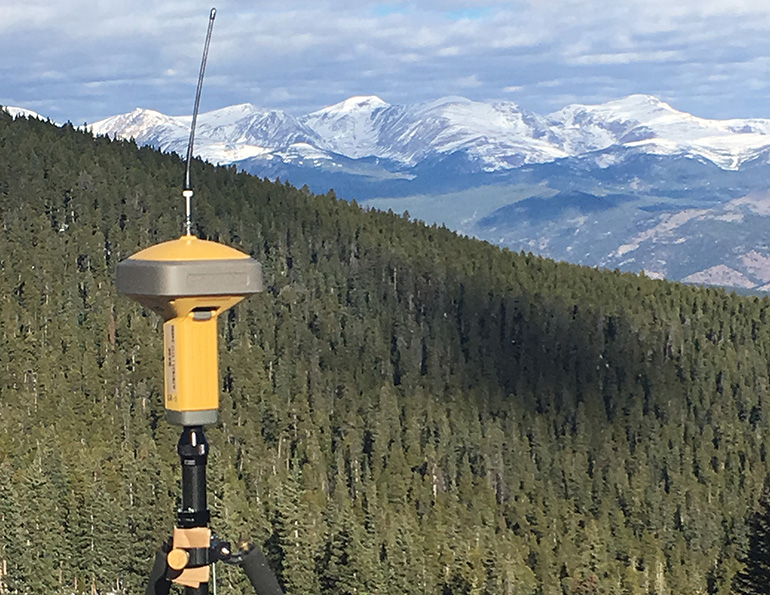
Optimal snow depths are based on what Rowlett calls “a digital terrain model of the groomed area,” typically generated by using laser-controlled Lidar mapping. The terrain survey can be done by plane, drone, or on the ground by hand or machine. Once an accurate map has been created, adjustments in snow-depth decisions can be made based on accumulated data—for example, identifying areas prone to snow loss or accumulation due to melting, wind, a weather event, or to variations in skier traffic.
The outlier is SnowGage. Rather than relying on a pre-surveyed Lidar model, SnowGage employs a sensor on the belly of a groomer to deliver snow depths based on the distance between the ground beneath the snow and the sensor. The data is then delivered directly to a screen in the operator’s cab. This technology, too, has a track record. Account manager Paul Kelly claims that SnowGage sensors, which have also been used in the oil and gas industry, for road surveying, and for military applications, are specifically designed to operate in tough environments.
COST VS. PRECISION
Kelly concedes that the precision of the system—accurate within five inches—might not match that of competitors’ systems, which typically claim accuracy to within an inch or so. But accuracy comes at a cost, and Kelly contends that the five-inch margin of error is adequate under most circumstances. In addition, the system is for “alpine grooming only,” says Kelly, meaning it isn’t applicable for constructing terrain park features.
Still, with “simple and affordable” being SnowGage’s mantra, the cost, $20,000 per groomer, is a fraction of what other companies charge.
For more precise depth measurements, and for the option of additional features such as fleet management, SNOWsat, SNOW HOW with iCON, Arena, and Snowright are the better options, but the price rises accordingly. Hefley figures the entry-level cost for an RDO system to be somewhere in the range of $35,000 to $60,000. Steve Young, president and owner of Snowright, pegs the cost of a three-groomer implementation—including hardware and software for both a base station and groomers as well as the initial mapping—at about $100,000. He admits that “the hardest hit is going to be the smaller guy.”
That said, there is always the option of phasing the system in with, say, one or two groomers in the first year, followed by an additional groomer per year after that. As SNOWsat sales manager Josh Nelson puts it, implementation is “scalable,” and the more groomers in the program, the lower the cost per groomer becomes, as economies of scale take effect.
Loon Mountain, N.H., has gone that route. It has employed a single, GPS-equipped groomer to measure snow depth for the last two winters until additional groomers can be brought into the fold. Snow surfaces manager Ken Mack provides operators of non-GPS groomers with GPS-derived depth data from previous days. While those groomers might not have real-time GPS feedback on snow depths, the previous days’ data gives them a good idea of where the thin and thick spots are going to be. It is a great improvement over what Mack calls snow depth perception that was purely anecdotal.
PONDERING THE ROI
How quickly a resort recaptures its return on investment depends, of course, on several variables, including the size of the groomer fleet, prevailing weather conditions, the amount of terrain covered, and length of season. Nevertheless, those who are pushing the technology insist that the ROI can be remarkably quick. Andreas Muigg, head of product portfolio management at PRINOTH, says resorts should see the payback by the second or third year.
On its website, Snowright claims a cost reduction of $1,000 per acre annually; if that figure is accurate, the savings add up pretty quickly. Nelson analyzes the payback differently, estimating that an area can realize a 10 percent savings in the cost of power, water, and labor in year one. “In the second season,” he adds, “you can add another 10 percent on top of that.”
Resort experience tends to back up these claims. Wachusetts’ Hayward reports that the system has been so precise that the resulting efficiency in snowmaking is encouraging the area to seek a rebate from its electric utility, thanks to the energy savings.
ANCILLARY BENEFITS
While the efficiency of snow-depth management might be the principal benefit of GPS systems, there are noteworthy ancillary benefits as well. In most cases, the hardware installed in groomer cabs is transferrable, and thus able to be used for summer chores as well. “You can install the system in anything,” says Nelson, “competitors’ machines, loaders, trucks, mowers.”
Also noteworthy is an acceleration of the learning curve in training new groomers. What Hefley calls “intuitive software” makes it relatively easy for new cat drivers to get up to speed, reducing the errors and guesswork inherent in the training process. This benefit is particularly valuable at a time when several resorts are reporting a marked turnover from experienced groomer operators to newbies.
STICKY WICKETS: ACCURACY AND COMMUNICATIONS
Yet even as acceptance of GPS technology grows, there remain pockets of resistance. The cost of the investment is a principal reason, says Muigg, but a couple of technological issues continue to raise flags. Chief among those is communication; mountain environments, especially those with lots of trees, present a particular challenge in trying to maintain the necessary continuous contact with GPS satellites.
Companies are teaming with client resorts to devise various solutions, including combinations of cell boosting, wi-fi, the size and positioning of multiple antennas on groomers, and UHF radio communications. One factor working in favor of any GPS user is that the family of satellites is growing. The number of satellites in the U.S.-based GPS constellation is about 30, and with Russia’s Glonass system and Europe’s recently launched Galileo system, the overall constellation swells to more than 80 satellites. Muigg says more hardware should be in orbit soon, with China and India close to launching systems of their own.
While the major players in GPS-guided snow-depth management claim accuracy to within about an inch, at least one grooming operator expressed disappointment with the actual precision of snow measurement. This might be due to inaccuracies in the initial Lidar mapping, rather than the GPS technology. At Loon, Mack discovered the Leica-measured blade height was within a two-centimeter margin of error, but calculating ground height, according to the Lidar survey, was less certain.
SNOWMAKING INTEGRATION?
While current systems are generally proving cost-effective and reliable when it comes to snow-depth management and grooming planning, the integration with snowmaking operations and software appears to still be a work in progress.
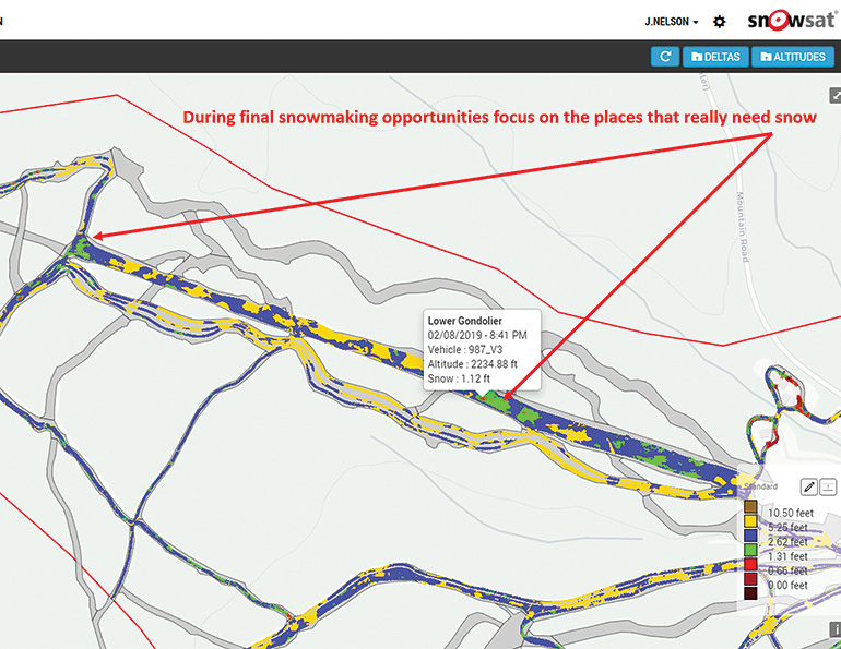 PistenBully’s SNOWsat and other GPS snow-depth management systems can accurately identify places where more snowmaking is needed, further improving the efficiency of mountain operations.
Still, translating snow-depth data from GPS-equipped groomers into the snowmaking decision process “is the future of where this has to go,” says Muigg, “to have everything in one spot.”
To reach that future, some GPS companies have joined forces with some snowmaking companies, particularly in cases where a previous partnership already existed, such as with PRINOTH and DemacLenko. But the overlap—“sharing snow depth data directly into snowmaking systems,” as Nelson puts it—has yet to happen. That is presumably an issue that future software upgrades, over time, should alleviate.
“Right now, I am working with two separate screens,” says Mack—one for snowmaking and one for GPS data.
Dave Hagerman, senior manager of slope and vehicle maintenance at Winter Park, Colo., is in a similar position. “We’re still a step away” when it comes to GPS-snowmaking coordination, says Hagerman. “To do that, you have to have automation in your snowmaking, and right now we have no automation.”
Regardless, any GPS-controlled grooming system not working hand in glove with a snowmaking operation would ultimately seem like a case of the right hand not knowing what the left hand is doing.
EVOLVING INTO THE FUTURE
So the GPS writing might be on the wall. “Five years ago, [there was concern] about the investment and not the benefit,” says Muigg. “Now there is no more debate that this is the way of the future.”
Where the technology goes from here, and how operators choose to use it, is still evolving. “This technology can go anywhere your imagination can take it,” says Winter Park’s Hagerman, as the resort discovers different ways to apply the technology and the data it generates. Nelson notes that at PistenBully, “the trend is toward putting it in every new cat.”
Full automation of grooming might seem a logical next step. “It has happened in farming and mining, and there is all the technology there to make it work,” says Rowlett. Even so, he’s in agreement with others in the GPS industry that full automation is likely a decade or more away.
Full automation might seem like pure Jetson-esque fantasy in today’s grooming world. But hey—just a few years ago, the snow-depth precision made possible by GPS technology seemed fantastical, too.